
Municipal Planning: Where Housing Policy Hits the Street
...And the street may never recover

Sometimes the general can be understood only by looking at the particular. Ongoing national debates over housing aren’t about Parliament Hill in Ottawa or various provincial legislatures. They’re about homes on streets in actual communities.
To that end, I’m going to focus on just one official rezoning effort for just one neighbourhood in Toronto: the city planning initiative called Growing Marlee-Glencairn. Understanding what drove the city to launch this multi-year effort and how that inspiration is defining both their policy and strategic choices is going to take us to some interesting places.
At a quick glance, the primary problems motivating the exercise seems to be:
The "population and jobs per hectare” density of the neighbourhood is well below the provincial goal of 200.
Very few commuters are accessing the subway system through Glencairn Station. There were just 5,878 of them on a typical weekday in 2023-2024.
When placed in the context of policies encouraging high-density housing wherever possible, the study team found that the obvious solution is to pack more residents into the area. The official rationale for the study is to:
“Guide growth, align with provincial density requirements around transit stations, and provide for a resilient and inclusive complete community”
It’s just a bit bizarre that provincial guidelines require the disruption of stable communities and coercive micromanagement of personal life choices to justify the existence of an under-performing transit system. But the Growing Marlee-Glencairn planning documents are yet more ambitious. This is clearly about much more than provincial compliance.
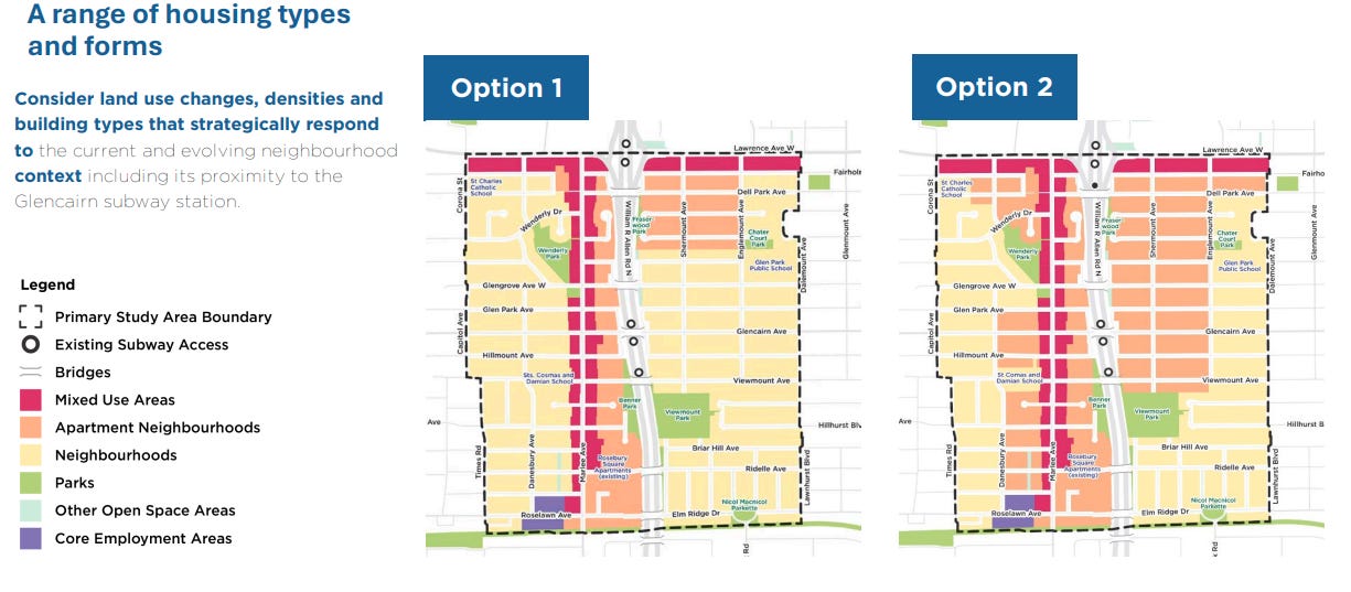
The most recent documentation available right now is the Community Roundtable Presentation from last December. Various combinations of possible zoning and infrastructure changes were presented. To be sure, no final decisions have been made yet and city staff are apparently still available for community feedback (my email-based feedback to Study officials sent on March 22nd did - on April 17th - inspire an invitation to provide feedback at a community meeting).
But it’s remarkable that the process has moved this far with such a narrow scope of discussion. Here’s some of what seems to be missing.
The active policy goals - and especially the key density goals - don’t seem to account for the recent collapse of immigration rates and the condo market meltdown. Why displace a healthy community to address external conditions that no longer exist? And even if those concerns were still valid, the main focus of the city plan is on affordable housing rental units: they seem largely uninterested in solving the home ownership crisis.
I would hope that such high-visibility trends should impact planning, but the documentation offers no indication that anyone’s actually been following developments.
There are many plans for improving pedestrian and transit accessibility, but nothing addressing either existing traffic congestion or the significant increased congestion that’ll come from adding 20,000-40,000 new residents to the area.
Even by Toronto standards, things can already get pretty nasty in Glencairn-Marlee. There are multiple quiet residential intersections that, for 90 minutes a day, host unrelenting backups of upwards of 50 vehicles coming from three directions as they desperately attempt to move north (both morning and afternoon). This kind of thing already happens regularly across the area.
The documentation is heavy on proposed “streetscape improvements”. Streetscaping will often include wider sidewalks, protected bike lanes, improved pedestrian crossings, landscaping with trees, public art, and traffic calming measures such as curb extensions. What those all share in common is that they take up space, which can come from only one source: vehicle lanes.
Now this isn’t to say that there’s no good argument to be made for streetscaping. But the current framing places an enormous unaddressed elephant in the room: where should all the existing and extra cars, trucks, buses, and delivery traffic go?
Alongside streetscapes is the goal of achieving a “broader public realm”. As far as I can tell, that would create open design spaces that encourage pedestrians to make use of retail and even residential resources (food concourses and apartment lobbies, I guess). How compatible that might be with an increasingly low-trust society is unclear.
In fact, security and crime prevention are pretty much ignored throughout the plan. There’s no indication that thought has been devoted to managing any of the second-order pressures that could come alongside heavily expanded low-income housing.
The planning does seek to “provide new housing that meets the needs of people of all stages of life”. Well, people of all stages of life besides families raising children, that is. The official planning discussion is exclusively and explicitly focused on removing single-family homes wherever possible and replacing them with high-density housing. Given the well-documented correlation (although not necessary causation) between denser housing and lower fertility, that could be a problem.
I’m not sure depressing fertility should be a policy goal for the City of Toronto or the Province of Ontario.
A (minor) element in the “community focused services and facilities” discussion includes creating new public library access. Given how in-person visits to existing Toronto Public Library facilities have dropped by more than 30 percent over the past twenty years, I’m not sure whether that’s a useful idea.
Great piece
It seems like "guiding growth" mostly consists of building a physical community that no one really wants to live in, while insisting "you're gonna love it - it'll be great".
"...coercive micromanagement of personal life choices to justify the existence of an under-performing transit system" is also a perfect description of Ottawa.